
Hiking the truly spectacular Skye Trail via the Bad Step!!
The Skye Trail is a challenging 80-mile trek across the Isle of Skye, from Rubha Hunish to Broadford. Skye is a truly spectacular place and considered one of the most beautiful of the 790 islands in Scotland!!! Passing by rugged cliffs, lochs, ruins of deserted villages, the Trotternish Ridge and the Black Cuillins. This trail is recommended for experienced backpackers due to the need for self-reliance and is not waymarked so requires strong navigational skills. I got lucky with 5½ days of hot sunny weather though it was really tough carrying a full rucksack for the 7 days trek.
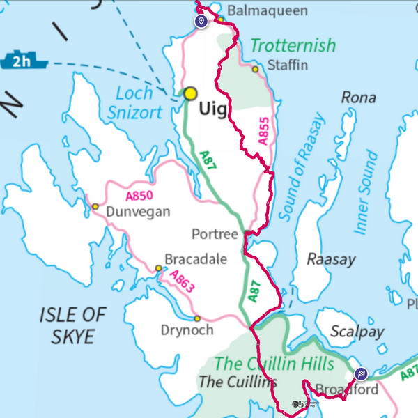
The Skye Trail is typically completed in 6 or 7 days. I was debating whether to hike the trail in 6 days but if you’re going add-on the Bad Step / Loch Coruisk alternate route then it’ll make the hike much more difficult in 6 days. If you want to take your time and enjoy the scenery, your best hiking the trail in at least 7 days.
If trail runners can run the Skye Trail using trail running shoes, then there’s no reason why you can’t use hiking shoes. It’s the first time I’ve used hiking shoes on a long-distance trail. If you’re expecting some dry weather then you could just use gaiters to prevent water and dirt getting into the shoes and walking poles to help with stability. But if you’re expecting really wet and boggy conditions then obviously use hiking boots.
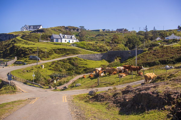
Day 1: Broadford to Camas Malag Bay
I was just about to start the Skye Trail in Broadford when I noticed a leak in the rucksack. Turns out a can of ginger had burst inside the food bag. It was kind of fortunate this happened at Broadford since I could clean the stickiness in the toilets. So, I had the opportunity to spend more time in Broadford but was delayed by 1hrs 30mins. After starting the hike, I wanted to find somewhere to test a new drone. Sadly, the drone did not work and mistakenly thought there were flying restrictions in Skye. Later found out at home, it was a faulty USB connector cable. Just thought that the Skye Trail is going to be an eventful journey!!
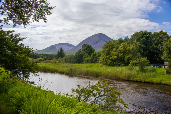
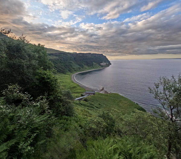
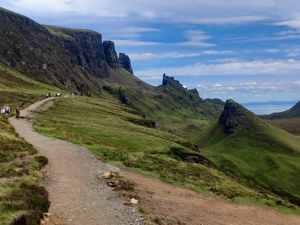
The start of the trail is very scenic while walking alongside the Red Cuillins. Once reaching the coast, it becomes very tranquil with beautiful views of the sea and the mountains of the Isle of Rum!! Passing by the abandoned village of Boreraig which was brutally cleared during the Highland Clearances in the 1850s to make way for sheep. Then walking along by the coast with high dramatic cliffs towering above. The path suddenly disappeared and in front looked impassable due to the high tide. The GPS was not accurate and thought the route was supposed to be on top of the cliffs. So, I spent half an hour trying to figure out how to continue on the trail. I met a couple of people going in the opposite direction and they were oblivious to the issues here when walking South to North. Backpackers would not have had this issue when walking the most common direction, North to South.
I was really behind with time now. One of my shoulders started becoming sore probably due to the rucksack being too heavy. So, I got in the bad habit of relieving the pain by placing a hand on the shoulder while the other hand had the 2 walking poles. I was on a stony path with very slight decline and I went flying and landed on the ground with my face just next to the ground!! Within half a second, the heavy rucksack pushed my face into the ground with small stones!! It seemed like my head was burst opened!! I felt trapped on the ground because the heavy bag was on top of me. I managed to stop the bleeding pretty quick once getting up although my knee and hand were bruised. Lessons learned: Don’t use an overly heavy rucksack and always use a walking poles with each hand.
It’s difficult to find a place to camp here and I could not locate a stream to refill the water. In the first couple days, some of the streams had a funny colour and did not taste as nice so best to bring a water filter. Luckily, I discovered a cracking place overlooking the Camas Malag Bay. I just felt so sore that night and wasn’t sure how the Skye Trail was going to go.
Day 2: Camas Malag Bay to Elgol
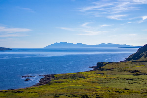
There was still quite a distance to the small fishing village of Torrin, the planned destination for the end of first stage. I stopped by Camas Malag Bay to make some breakfast on the beach and then swiftly walked along the road to Torrin. This is a very scenic village at the bottom of the Red Cuillins!! The second stage is supposed to be easy so I had to make up for the lost time. I was hoping a shop would be open as I was really wanting some fizzy drinks but wasn’t looking promising. Then to my delight a burger van was open that had a fantastic viewpoint of Blà Bheinn (also known as Blaven)!! This was another really warm day and I questioned if long distance treks during hot conditions were for me.
You can add Blaven on to your walk on this stage therefore missing out on Elgol. Blaven is one of the easiest Munros on Skye although it’s a really steep mountain. It’s worth noting there’s a tricky intimating scramble to a Munro-top before descending the South ridge to Camasunary Bay. I decided not to hike Blaven to conserve energy and really wanted to see the airy coastal path near Elgol.
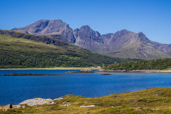
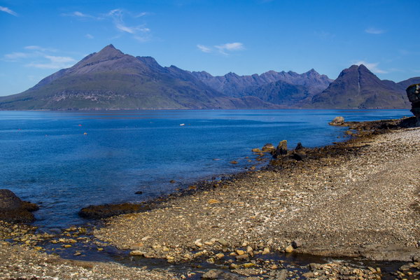
The views of the Black Cuillins are absolutely amazing from the Blaven summit!!! The Black Cuillins is the most complex and challenging mountain to climb in the British Isles!! There are about 36 peaks along a narrow 12 km ridge and there’s no other mountain like this in Scotland. This includes Scotland’s most difficult Munro, the Inaccessible Pinnacle which requires a graded rock climb and an abseil.
After leaving Blaven carpark, the trail ascends 475ft through a boggy forest. Once on top, there’s stunning all round views of the Red Cuillins!! The main road to Elgol heads up on a hill but the path is down towards the coast. You walk through this massive forest and some bits were eerie and not signposted. After reaching the small settlement Glasnakille, there’s a trek through moorland to reach Elgol.
There’s an impressive cave near Glasnakille called the Spar Cave but you must check the tide times. You only have access to the cave 1 hour of either side of low tide. You need to be well-equipped as even at the lowest tide the water could be at least knee deep. There’s also the Prince Charlie’s Cave near Elgol which is only accessible a couple of hours either side of low tide as well.
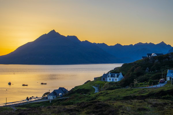
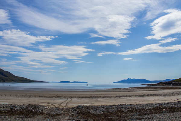
It was great timing to have my first visit to Elgol during an amazing sunset so I had good first impressions of Elgol!!! Much of the village is actually on a hill and it’s difficult to find flat land to pitch a tent because of the hill. Elgol is really beautiful with the Black Cuillins mountains across Loch Scavaig and the mountain that stood out the most is Sgùrr nan Eag!! I actually planned to have a fish and chips here but was too late and also never seen the van anyway. It’s worth having a rest day at Elgol as there’s boat trips to places like Loch Coruisk.
Day 3: Elgol to Sligachan via the Bad Step
This is the stage I was looking forward to the most and was the hardest hike with 4,652 ft altitude gained. I made the decision to hide my drone and some other stuff so as to lighten the rucksack. Which meant extending the trip by 1 day and coming back to Elgol. This is the day of the Bad Step and it’s not a good idea to scramble this with a rucksack that’s too heavy.
After Elgol there’s an airy coastal path that has numerous sketchy steep drops down to the sea below. It reminds me of the end of Loch Lomond on the West Highland Way but it’s sketchier. I wouldn’t underestimate this as it’s a little nerve racking at times but it’s all part of the adventure. Once finishing the coastal path, you’ll reach Camasunary Bay which is one of the finest bays on the Island!! There are no roads here and it’s a couple hours hike from Elgol. If taking the Bad Step / Loch Coruisk alternate route, you must cross a river but it wasn’t difficult when using my crocs sandals.
Then the path heads around the coast towards the notorious Bad Step while taking in absolutely amazing views of the Cuillins!!! It’s about a 1-hour hike to the Bad Step and the closer I got the more anxious I became. I had no idea how this was going to work out. The Bad Step is an airy grade 2 scramble about 15ft above the sea so you’ll need a good head for heights. It’s at a very remote location though other outdoorsy people do travel to Loch Coruisk but mainly by boat. The reason I choose South to North is because it’s easier traversing the Bad Step in that direction.
The path directly led to a scramble that resembled the Bad Step which is another issue when hiking South to North. I ascended this first and it’s more dangerous and includes a rock climb. So, I came back and had a wee nosey to see what was lower down nearer to the sea. I scrambled up another route and wasn’t sure if this was the Bad Step. So came back again and was about to give up and head back to Camasunary Bay. Then I made one last attempt and was very relieved to make it across the Bad Step without any issues. The exposure is not as bad as I thought and if I was to do it again, it would be a lot easier. I’m not going to lie, it was nerve-racking and taking the wrong route at first made it more daunting!!
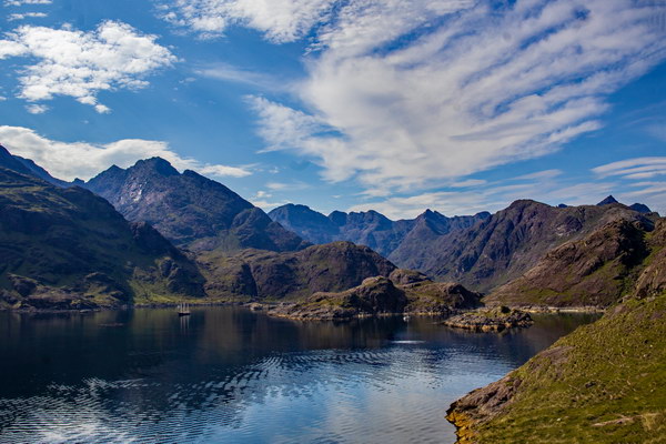
I now kind of understand why some people say you’ve not done the Skye Trail if you’ve not conquered the Bad Step. Walking towards the Black Cuillins and then through Loch Coruisk is so much more beautiful than hiking the usual route from Sligachan to Elgol. Loch Coruisk is a hidden freshwater loch surrounded by the peaks of the Cuillin mountains. It’s truly a hidden gem and the water has a beautiful blue-green colour!! The only way to reach Loch Coruisk is via the Bad Step or 11km hike from Sligachan or a boat trip from Elgol. It’s worth noting it’s very dangerous to traverse the Bad Step in wet conditions or blowing a gale as there is a risk of falling into the sea.
After the Bad Step, it’s not like you start on a nice path, as there’s more scrambling over large boulders. The max temperature was 26 degrees and it must’ve been one of the hottest days of the year on Skye!! Once reaching Loch Coruisk, I was so thirsty I drank one litre of water!!! Then had an unexpected 1000ft climb up to the bealach of Sgùrr na Strì though it was really tough carrying the full rucksack. When reaching the bealach I was rewarded with amazing views of the Red Cuillins and Blaven!!! The other side of the mountain range that I saw the previous day. I was debating whether to tick off Sgùrr na Strì but it’s worthy of a return visit to camp on top of the sub2000. As the summit has supposedly one of the finest views in the British Isles!!
Maybe it wasn’t a good idea to walk the 6 miles to Sligachan campsite. It was a relentless walk and arrived there just before it became really dark. Sgùrr nan Gillean is an astonishing looking mountain from Glen Sligachan!!! I’m not surprised to read it’s possibly the most famous of the Cuillin peaks!!
Day 4: Sligachan to Portree via the Braes
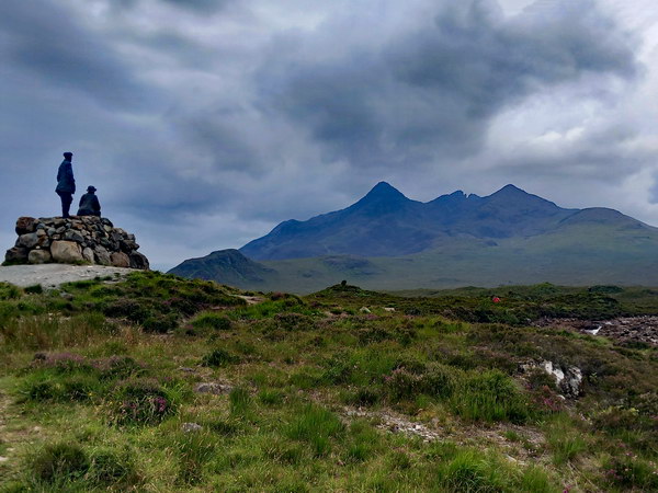
After the amazing weather I had the first 3 days, the weather took a turn for the worse on the 4th day. The batteries had run out on my camera so I’ve struggled to find more decent pictures for rest of the trek. But did capture this phone shot showing the Skye climbing pioneers John Mackenzie and Professor Norman Collie admiring the northern part of the Cuillin mountains!
The start of the hike alongside Loch Sligachan was very atmospheric!! The only issue here was sometimes you would leave the path and unnecessarily hike over difficult rocks on the beach, but by ascending you’ll find the correct path. Once reaching the Braes peninsula you walk on a road along the coastline but it was dreich for much of the remaining hike. The last 2 miles from Portree is quite adventurous with walking alongside a river, through a forest and by the sea.
Unfortunately, I ran into some bad luck!! Firstly, I got soaked when walking through a narrow path with wet vegetation and then the elastic cord of my waterproof overtrousers ripped off. I’m so glad it stopped raining in Portree as I couldn’t see anywhere to shelter from the elements!! It’s not fun walking about a busy wee town on your own with a heavy rucksack. The only positive thing to happen in Portree was indulging in a lovely fish and chips!!
I planned to travel by bus to the campsite though the last bus had already been. Somehow, I misread the timetable online or the website was inaccurate. Then waited at the taxi rank but frustratingly there were no taxis anywhere. The last check-in time was approaching which put more pressure on getting to the campsite. According to Google maps it’s a 30min walk to the campsite with 200ft climb so should’ve done this sooner. It was much more peaceful once reaching the campsite and had the chance to relax.
Day 5: Portree to Bearreraig Bay
Portree is the capital and largest town of the Isle of Skye and is the main town to restock supplies. Usually, tourists shop at the Co-op near the harbour although this is a tourist trap. There’s a much bigger Co-op 20 mins walk (also get bus) which has a wider variety of products and at a cheaper price. I had a pleasant morning in Portree which made up for the rubbish time I had there the previous day. It was really good timing that I had an issue with the overtrousers in Portree as I bought new overtrousers from an outdoorsy shop. I felt much better after having a shower, drying wet clothes/shoes and charging a powerbank at the campsite.
The walkout from Portee along the coastal path is very scenic!! This is the first time walking on top of the cliffs though there is a steep ascent to reach the top. I was very impressed with the views, especially looking down the steep cliffs. There is an alternative route for this stage that heads up Ben Dearg which is the southern end of the Trotternish Ridge but I am glad I chose the coastal path as I think it’s more scenic. It was back to being a lovely sunny day and even passed a couple of 1000ft summits overlooking the sea.
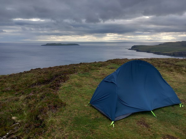
I planned to camp at Bearreraig Bay which involves a very steep descent. I was really low on water and just couldn’t find any. At first, I did not know how to reach the bay but luckily downloaded a Walk Highlands route. Bearreraig Bay must be one of the most beautiful bays in Skye but sadly spoiled by a Hydro-electric power station. When reaching the bay, there’s a river in spate making a lot of noise, probably due to the power station pumping water too fast. I think you could have found a way across but I refilled water and headed back up to the top of the cliffs to pitch the tent overlooking the bay.
Day 6: Bearreraig Bay to Beinn Edra
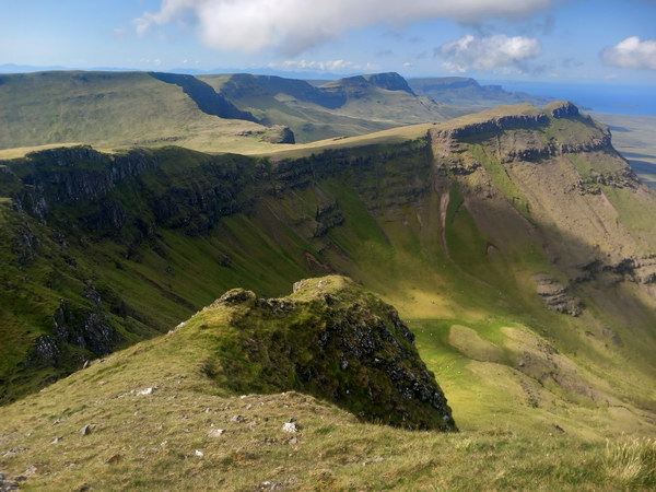
This stage is really long and the most demanding hike of the trail. The Trotternish Ridge is very exposed and has little escape routes if encountering bad weather. Be prepared and always take a paper map and compass with you. It’s worth buying the Skye Trail XT40 (1:40,000) from Harvey Maps. The Trotternish Ridge is a truly spectacular place and if you get lucky with the weather, you’ll see beautiful awesome scenery!!! I split the last 2 stages more evenly so instead of one extremely tough day, the 1st day was 14 miles and the 2nd was 16 miles. This is only ideal if wild camping and not staying at accommodation in Flodigarry/Staffin.
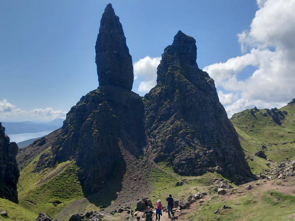
The Old Man of Storr is a prominent rocky pinnacle on the mountain called the Storr. The trail is a very popular tourist attraction on Isle of Skye and not surprisingly very busy. The Storr at 2,359 feet is the highest peak of the Trotternish Ridge. The summit is not actually on the Skye Trail but you can hide your bag and take a detour to bag the Fiona. The Storr really is a stunning mountain and the views on top are fabulous so really worth the detour!! Hartaval is another Fiona on the Trotternish Ridge and at 2,188 feet is the highest point on the Skye Trail.
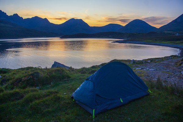
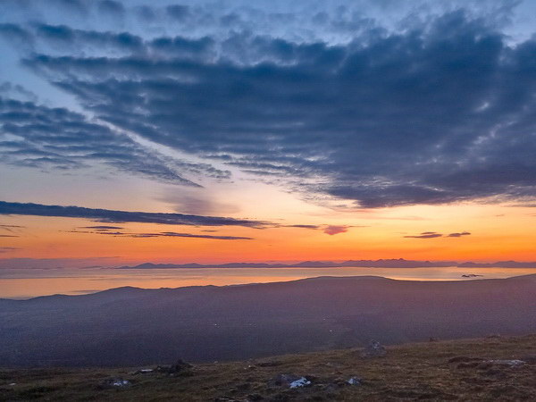
The weather could have turned either way but fortunately, the weather turned for the better. In fact, I was actually concerned the weather was forecast for more hot weather with clear skies. There’s no water on the ridge, apart from streams around the Storr mountain, but once leaving Storr, there’s no water until reaching the Quiraing car park. I refilled 2.3 litres of water which adds like 2.3kg of weight to the rucksack. If you’re going to attempt this ridge between Storr carpark and Flodigarry in the one day then maybe best to hike from North to South as you’ll have much more energy. I summit camped on Beinn Edra which had an incredible sunset over the Outer Hebrides with the Quiraing slightly over to the right.
Day 7: Beinn Edra to Shulista”
The weather forecast for this day was sunny with rain arriving at 5pm. So, this was perfect to hike the Quiraing. The Quiraing was formed by an ancient landslip that left behind an area of dramatic and bizarre rock formations. It’s situated on the northernmost part of the Trotternish Ridge on the Isle of Skye. The Quiraing is very popular due to its breathtaking and dramatic scenery and is one of the best hikes on the Island!!
I’m glad I did not attempt to reach Flodigarry the previous day as it took a further 4 hrs to reach Flodigarry with fresh legs. I stopped by at the Flodigarry hotel for 2 pints which was actually my first opportunity to have a pint. Normally I would sit outside during the hot weather when having a drink. But because I’d been in the hot weather so much during the trail, I just needed a relaxing drink indoors. The chilled 2 pints were lovely and a great way to rest as there was still a further 4 hrs to walk until reaching the Lookout Bothy at Rubha Hunish.
This stage has more coastal clifftop walks with a couple of bits unexpectedly sketchy. The forecast was correct and rain started at about 5, so I was more interested now in reaching the bothy. The bothy was busy and there’s only limited flat land there to pitch a tent. As the evening went on, it became busier and just wished now I camped somewhere away from the bothy. This is technically not the end of the Skye Trail but it’s really nice to camp just on the clifftop. The end (or beginning if travelling North to South) is at the phone box on the Shulista road end which is only a 30 min walk. If you have spare time, you could walk around Rubha Hunish headland but probably best to download an offline route as the descent is near steep cliffs.
Day 8: Bus trip to Elgol and camp at Broadford
I still had to pick up the drone in Elgol so this was an opportunity to spend one last day on the Isle of Skye. The Stagecoach app was really helpful for planning the 3 bus journey from Shulista to Elgol. If travelling by public transport, I would recommend using this app to plan bus routes and check bus times. The last bus at Elgol is at 4.30pm on the Friday and with no more buses until Monday. I had a 20 min window to pick up the drone and catch the last bus. Fortunately, everything did go to plan apart from getting soaked when getting off the bus.
I found a nice spot to camp on Glen Sligachan, just outside Broadford (campsites were full). Since I never had any celebrations when finishing the Skye Trail, I had the opportunity for a wee celebration at Broadford on the Friday night. So, I ate fish and chips at the sea front and then hit the Gabbro Bar for the night.
I had a choice of hiking other long distance trails but after reading about the Skye Trail last year, it was a no brainer to pick this one. So I would highly recommend doing the Skye Trail but best to gain more backpacking experience by walking the West Highland Way first. Hope you’ve enjoyed reading about my Skye Trail adventures. If I can inspire just one person to hike this trail then writing this blog would be all worthwhile. If you have any questions, please leave them in the comments and I’ll reply as quickly as I can.
Strava statistics
| Day | Description | Distance | Time |
| 1 | Broadford to Camas Malag Bay | 10.25 miles | 7 ¾ hrs |
| 2 | Camas Malag Bay to Elgol | 12.25 miles | 10 hrs |
| 3 | Elgol to Sligachan via the Bad Step | 15 miles | 10 ¾ hrs |
| 4 | Sligachan to Portree via the Braes | 10.25 miles | 6 ¼ hrs |
| 5 | Portree to Bearreraig Bay | 11 miles | 9 hrs |
| 6 | Bearreraig Bay to Beinn Edra | 14 miles | 10 ¼ hrs |
| 7 | Beinn Edra to Shulista phone box | 18 miles | 9 hrs |
Altitude gained: 15,973ft (4869m)
Distance: 90.7 miles
Time: 65 hrs
Hiking/camping gear List
| Technology | Hiking | |||
|---|---|---|---|---|
| Item | Weight | Item | Weight | |
| Canon EOS R50 | 519 | Osprey Exos Pro 55 Backpack | 940 | |
| Gopro Hero 12 | 154 | Backpack raincover | 81 | |
| DJI Mini 3 Drone | 258 | Packaway jacket | 306 | |
| Drone controller | 377 | Packaway overtrouser | 300 | |
| iPhone 12 | 164 | Gloves | 69 | |
| Canon microphone | 75 | Hat | 80 | |
| Gopro head mount | 75 | Ankle gaitors | 75 | |
| Gopro stand | 13 | Fleech x 2 | 510 | |
| Mini Octopus Tripod | 41 | Shoulder Strap for rucksack | 56 | |
| Phone tripod adapter | 25 | Waterproof phone cover | 40 | |
| Canon LP-E17 spare battery | 31 | Silk hankies | 6 | |
| DJI Mini 3 spare battery | 80 | Pants | 79 | |
| Powerbank 20000mAh | 351 | Compass | 17 | |
| USB charger cables | 60 | Headlight | 55 | |
| 6 hiking socks | 400 | |||
| Brim hat | 56 | |||
| Large stuff sack | 18 | |||
| Compression bag | 75 | |||
| Insulated cool bag | 45 |
| Camping | Cooking/Food | |||
|---|---|---|---|---|
| Item | Weight | Item | Weight | |
| Ultralight 1 Person Tent | 1703 | OEX Heiro + stove holder | 394 | |
| Foam sleeping mat | 247 | C100 Xtreme gas | 195 | |
| Inflatable pillow | 85 | Dehydrated meals x 4 | 1061 | |
| Ultralite Sleeping Bag | 955 | Rice/pasta x 4 | 267 | |
| Tent LED light | 47 | Porridge x 3 | 160 | |
| Foldable foam seat | 16 | Serial bars/choc x 9 | 243 | |
| Plastic tent mallet | 80 | Rolls | 274 | |
| Midge headnet | 107 | Sweets | 36 | |
| Microfiber sports towel | 100 | 2 x 200ml vodka | 399 | |
| Toothpaste | 31 | 100ml orange juice | 84 | |
| Handwash | 72 | Water | 500 | |
| Shampoo + Conditioner | 66 | 1 litre water bottles x 2 | 60 | |
| Shower gel | 68 | 330ml water bottle | 16 | |
| Crocs sandal | 215 | |||
| Toiletry bag | 3 | |||
| Accessories bag | 14 | |||
| Drone bag | 10 | |||
| Tech zip bag | 7 | |||
| Small bits zip bag | 7 | |||
| Camera bubble wrap | 8 |
| Miscellaneous | Other | |||
|---|---|---|---|---|
| Item | Weight | Item | Weight | |
| 150ml sun tan lotion | 85 | Hiking Poles | 605 | |
| Bath sponge | 39 | Garmin Instinct 2 Solar | 53 | |
| 2 way USB 2A mains socket | 32 | Wallet (with coins) | 53 | |
| Toothbrush | 9 | Samsung A13 | 197 | |
| Toothpaste holder | 2 | Silk hankies | 6 | |
| Toothpick | 1 | |||
| Comb | 7 | |||
| Washing sponge | 2 | |||
| Disposable razor | 7 | |||
| Painkillers | 6 | |||
| Plasters | 6 | |||
| Scissors | 9 | |||
| Needle and thread | 1 | |||
| Ear plugs | 2 | |||
| Plastic spoon/fork/knife x 2 | 16 | |||
| Whistle | 9 | |||
| Walking The Skye Trail | 132 | |||
| Skye Trail map | 44 | |||
| Toilet roll | 9 | |||
| Hankies | 25 | |||
| Rubbish and laundry bag | 12 |
Rucksack total weight = 12.9kg
Feel free to have a look around www.fraser-king.com to see the other fabulous pictures I’ve captured during my hiking journey!!
Please follow me on Instagram, on YouTube, on TikTok and Facebook.


